 Aero Academic
Part 107 sets hard limits on how you fly in any weather: no higher than 400 feet above ground level, at least 3 statute miles of flight visibility, 500 feet below and 2,000 feet horizontally from cloud, and no faster than 87 knots groundspeed. Beyond those minimums, you need to read weather sources and judge how density altitude, wind and storms affect a small aircraft.
Checked against: 14 CFR Part 107 (current eCFR text), sections 107.31, 107.49 and 107.51; FAA-S-ACS-10B Areas of Operation III (Weather) and IV (Loading and Performance).
| Limit | Value | Detail |
|---|---|---|
| Groundspeed | 87 knots (100 mph) | Maximum groundspeed of the small unmanned aircraft |
| Altitude | 400 ft AGL | Exception: within a 400 foot radius of a structure, and no higher than 400 ft above the structure’s immediate uppermost limit |
| Flight visibility | 3 statute miles minimum | Observed from the location of the control station; the average slant distance at which prominent unlighted objects can be seen and identified by day, and prominent lighted objects by night |
| Distance from clouds | 500 ft below and 2,000 ft horizontally | Minimum distances of the aircraft from clouds |
| Task | Elements | What to be able to do |
|---|---|---|
| III.A Sources of Weather | METAR, TAF, weather charts, ASOS and AWOS, internet weather briefing | Pick the right source and read it for flight planning |
| III.B Effects of Weather on Performance | Density altitude; wind and currents; stability, pressure and temperature; air masses and fronts; thunderstorms and microbursts; tornadoes; icing; hail; fog; ceiling and visibility; lightning | Explain how each changes the way a small aircraft flies and what you should do |
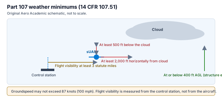
Section 107.51 requires the remote pilot in command and the person manipulating the controls to comply with four limits. Groundspeed may not exceed 87 knots, which is 100 miles per hour. Altitude may not exceed 400 feet above ground level unless the aircraft is flown within a 400 foot radius of a structure and no higher than 400 feet above the structure’s uppermost limit.
The minimum flight visibility is 3 statute miles, observed from the control station, and the aircraft must stay at least 500 feet below a cloud and 2,000 feet horizontally from it. Figure 1 draws these distances and Table 1 lists them. Notice that the visibility is measured from where you stand, not from the aircraft.
These four numbers are among the most testable facts in the course, and they are easy to mix up. A good memory aid is to write them as a set: 87 knots, 400 feet, 3 miles, 500 below and 2,000 across.
Section 107.31 requires that, with vision unaided by any device other than corrective lenses, the remote pilot in command, the visual observer if one is used, and the person at the controls can see the aircraft throughout the flight. The ability must be exercised by the pilot and the person at the controls, or by a visual observer.
This interacts with weather. Haze, glare, low sun and low cloud can make it hard to see the aircraft before you reach the 3 mile visibility minimum. If you cannot meet the visual line of sight requirement, you have to land, whatever the visibility number says.
Task III.A lists the sources: aviation routine weather reports (METAR), terminal forecasts (TAF), weather charts, and automated surface and weather observing systems (ASOS and AWOS), together with internet weather briefing. A METAR reports observed conditions at an airport, and a TAF forecasts conditions for the airport and its surroundings for a set period. ASOS and AWOS give automated observations.
Use the observation for what is happening now and the forecast for what is coming, and check both against what you see at the site. If the nearest reporting station is far from your location, treat its data as a guide and be conservative. In the US, wind, temperature and altimeter setting are reported in knots, degrees Celsius and inches of mercury.
Task III.B covers density altitude, wind and currents, atmospheric stability, pressure and temperature, air masses and fronts, thunderstorms and microbursts, tornadoes, icing, hail, fog, ceiling and visibility, and lightning. For a small unmanned aircraft the effects are often stronger than for a large aircraft because the aircraft is light and its power reserve is small.
Wind can exceed the aircraft’s ability to hold position or return, especially at higher altitudes where wind is stronger than at the surface. Thunderstorms and microbursts bring sudden wind shifts and heavy precipitation, and lightning is a hazard to the ground crew. Icing and fog reduce performance and visibility, and precipitation can damage electronics. If any of these are present or forecast, the safe decision is not to fly.
Density altitude is the altitude in the standard atmosphere at which the air has the same density as the actual air. Hot, high or humid conditions raise it, which reduces propeller efficiency and the power available, and shortens battery endurance. At a high density altitude, a small aircraft climbs more slowly and may not carry the same payload.
To estimate it, find pressure altitude by adding 1,000 feet for each inch of mercury the altimeter setting is below 29.92, then correct for temperature. Standard temperature falls about 2 degrees Celsius per 1,000 feet from 15 degrees at sea level, and each degree above standard adds roughly 120 feet. For a field at 1,500 feet with an altimeter setting of 29.82, pressure altitude is 1,600 feet and standard temperature is about 11.8 degrees. At 32 degrees, the deviation is about 20 degrees and the density altitude is about 4,000 feet.
Section 107.49 requires the remote pilot in command to assess the operating environment before flight, and the assessment must include local weather conditions, local airspace and flight restrictions, the location of persons and property on the surface, and other ground hazards. Weather is the first item on the list.
A simple routine works well: check the observation and forecast, compare them with the 107.51 minimums, check wind at the surface and aloft, think about what might change during your flight window, and decide in advance what triggers a landing. Write the decision rule down before you launch.
You plan a survey at 350 feet above ground level. The latest METAR near the site reports 8 statute miles visibility, a broken layer at 800 feet above ground level, and wind gusting to 22 knots. Check each 107.51 limit in turn. Visibility of 8 miles passes the 3 mile minimum. Altitude of 350 feet passes the 400 foot limit.
Cloud clearance fails. You must stay at least 500 feet below the cloud, and 800 minus 500 leaves a ceiling of 300 feet for the aircraft. Your planned 350 feet is 50 feet too high, so you either lower the plan to 300 feet or wait for the layer to lift. Then check the gusts: if your aircraft cannot hold position safely in 22 knot gusts, the flight is a no-go regardless of the numbers.
The point is that legal minimums and safe conditions are separate tests. Pass the regulation first, then apply your own limits for wind and the aircraft, and write both down before you launch.
Area of Operation IV covers loading and performance. Weight changes how long the aircraft can fly and how it handles, and balance affects control. The ACS ties this to weather because performance is lower at high density altitude, so a payload that works on a cool morning may not work on a hot afternoon.
Check the manufacturer’s limits, keep the aircraft within weight and balance, and reduce payload or shorten the mission when conditions are marginal. Battery performance also falls in cold weather and endurance falls with heavy loads and strong wind, so build a generous reserve into the plan and land with margin rather than at the minimum.
The most frequent mistakes are measuring visibility from the aircraft instead of the control station, forgetting the 2,000 feet horizontal cloud clearance, and applying the 400 foot limit without the structure exception, or applying the exception without the 400 foot radius condition. Another is relying on a forecast for a different location or time. The last is treating a flyable number as a reason to fly when wind or storms make the flight unsafe.
At least 3 statute miles of flight visibility, observed from the control station (14 CFR 107.51(c)).
At least 500 feet below the cloud and 2,000 feet horizontally from it (14 CFR 107.51(d)).
400 feet above ground level, with an exception near structures, and 87 knots (100 mph) groundspeed (14 CFR 107.51).
METAR, TAF, weather charts, ASOS and AWOS, and internet weather briefing for flight planning (UA.III.A).
Yes. Heat raises density altitude, which reduces propeller efficiency and power available, so the aircraft climbs less and may carry less payload.
https://www.aeroacademic.com/guides/us-part-107-weather-and-operating-limits